Trimble Marine GNSS Correction Sources
GNSS operations are only as good as their correction source!
The accuracy and integrity of GNSS can be greatly enhanced by using a GNSS correction service. GNSS correction sources take a variety of forms, but all deliver information that enhances GPS/GNSS precision and performance. Operating on a larger site a local GNSS base station may be the ideal option for the highest precision, whereas on a smaller site a virtual correction source could be the best choice.
Trimble GNSS RTK Base Station

For larger sites and those that include both site positioning and machine control operations, we recommend you deploy the Trimble SPS855 GNSS Modular Receiver as a permanent or semi-permanent base station.
Trimble VRS Now

Trimble VRS is a Network Real-Time Kinematic (RTK) subscription service operated by Trimble and delivered via the internet over a cellular network. Like Mobile Satellite Services (MSS), VRS is ideal for sites where it is not practical to set up a base station, for instance sites where there is no machine control or for initial reconnaissance tasks where a base station is not yet established. VRS does require an internet connection at the rover. Employing Trimble VRS technology, centimeter-level accuracy is available on demand, anywhere within the reference station network. This GNSS correction source is highly cost effective and efficient, easy to use, convenient, and, best of all, it is always on. Perfect for a range of industries needing high precision, including survey and construction, mapping and GIS, transportation, utilities, cadastral and areas having good cellular coverage.
Trimble xFill

Trimble xFill, powered by RTX technology, seamlessly runs in the background and is your backup coverage if a RTK or VRS correction source is interrupted due to cellular signal disruption or loss of UHF radio connectivity. Trimble xFill is a satellite delivered service that will maintain RTK precision for 5 - 20 minutes after the loss of an RTK correction stream (standard service) or for the entire duration of the disruption if you opt for the premium service. Therefore, you can continue to achieve survey-grade accuracy in remote locations without disruption, improving your productivity and your profits.
Trimble Internet Base Station Service (IBSS)
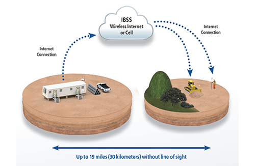
Trimble Internet Base Station Service (IBSS) broadcasts Real-Time Kinematic (RTK) data or Differential (DGNSS) corrections from your base station over the internet via wi-fi or a cellular network. This makes it easier and more economical to use high precision GNSS for site positioning or machine control over ranges that exceed the limitation of the UHF radio link. IBSS can also be used to augment UHF in areas of poor UHF coverage.
Mobile Satellite Services (MSS)
Satellite-based GNSS correction services include Trimble CenterPoint RTX, OmniSTAR and MarineSTAR. Mobile Satellite Services (MSS) deliver real-time and highly reliable positioning services worldwide, 365 days a year, 24 hours a day. MSS is delivered via geostationary L-band satellites, the signal is received at the GNSS rover by the Trimble GNSS antenna or GNSS smart antenna. Therefore, there is no requirement for a UHF radio or cellular network connection.
Trimble CenterPoint RTX is the premier, high accuracy positioning service for construction built on Trimble's exclusive RTX technology, providing sub-centimeter accuracy via satellite or cellular delivery worldwide. It helps you achieve the quality standards you need in less time for tasks such as machine control. Improve your productivity and your profits.

OmniSTAR services are offered worldwide by several overlapping satellite footprints, providing global and seamless coverage. These services deliver reliable GNSS positions with accuracies ranging from sub-meter to sub-10 centimeter level that enhance productivity and reduce cost. Ideal for a number of applications including marine construction.

MarineSTAR services are reliable and stable GNSS positioning services offered worldwide, and are available with accuracy of up to 8 centimeters, making use of dual frequencies and up to 4 satellite constellations. These services have been tailored for marine applications, including dredging and marine construction, navy and hydrographic, wind farm and oceanographic research sectors.
MSK Beacon
MSK Beacon refers to DGNSS or DGPS reference stations that transmit a free differential correction service on the 300 kHz band. These reference stations are maintained primarily by the International Association of Marine Aids to Navigation and Lighthouse Authorities (formerly IALA). Trimble marine GPS/GNSS receivers with the appropriate MSK capable antenna can use these corrections at no cost for sub-meter positioning.Satellite Based Augmentation System (SBAS)
The Satellite Based Augmentation System (SBAS) is based on GNSS measurements from accurately located reference stations deployed across a continent. Differential corrections and integrity messages are broadcast over a continent using geostationary satellites as an augmentation or overlay of the original GNSS message. Systems in place are WAAS (USA), EGNOS (Europe), GAGAN (India) and MSAS (Japan), providing corrections at no cost for sub-meter positioning.